
Classification of Surveying is a fundamental topic in civil engineering because almost every project begins with measuring and mapping the ground. Surveying determines the relative position of points on the earth, along with directions, distances, elevations and areas used to prepare layouts at a chosen scale. In practice, surveyors apply different Types of Surveying and Land Surveying Methods through reconnaissance, measurement, marking and plan preparation. These Surveying Techniques in Civil Engineering demand high precision and good mathematical skills to analyse field data accurately. By understanding Methods of Surveying Classification, including the difference between Plane vs Geodetic Surveying, engineers can select the most suitable approach for each site and structure. In this article, we explore how surveying is classified and where each type is typically used.
Table of contents
Classification of surveying
Surveying is divided into different types to ensure accurate measurement methods are selected for specific project requirements and field conditions.
Major Classification Methods are
- Primary Classification of Surveying
- Classification of Surveying Based on Field Nature
- Classification of Surveying Based on Purpose
- Classification of Surveying Based on Instruments Used
Each classification basis will be discussed in detail in this article, along with examples and applications in civil engineering.

Primary methods of Surveying classification
The primary classification methods of surveying depends on how the Earth’s surface is considered during measurements. Since the planet is an oblate spheroid, surveyors choose whether to treat it as a plane or as a curved surface, depending on the size and accuracy requirements of the project. This leads to two basic types of surveying used in civil engineering:
- Plane Surveying
- Geodetic Surveying.
Plane Surveying
In plane surveying, surveyors treat the Earth’s surface as flat and ignore its curvature. They assume the lines between points are straight and form plane triangles from them. Surveyors use this method mainly for small areas, generally less than 200 square kilometres, such as building sites, road alignments, and property boundaries. It is one of the common surveying techniques in civil engineering for local projects.
Geodetic Surveying
Geodetic surveying takes the curved surface of the Earth into account to achieve high-precision results. In geodetic surveying, surveyors treat the lines joining distant points as arcs and form spherical triangles from them. They use this method for large-scale mapping and projects that extend over vast areas, such as national surveys, long routes, and major infrastructure planning.
Classification of surveying based on field nature
Engineers classify surveying based on the type of environment where they take measurements, allowing them to choose suitable surveying techniques in civil engineering for each project.
Land surveying
Land surveying is the art of establishing or re-establishing corners, lines, boundaries, and monuments of property or land. This is based upon recorded documents, historical evidence, and present standards of practice. It helps in preparation of topographical maps, planning, and estimation of project works, locating boundary lines, etc. Land surveying methods are divided into the following types:
- Topographical surveying
- Cadastral Surveying
- City surveying
Topographical surveying
The main application of a topographical survey is the drafting of maps. Topographical surveys include surveying natural and artificial features such as rivers, hills, roads, canals, etc. It consists of horizontal, vertical, and angular measurements. The scale range is 1: 25000 to 1: 1000000.
Cadastral surveying
The main use of this surveying is in the documentation process while transferring ownership from one person to another. It helps in defining the boundaries and land area calculations. It is also known as the Public Land Survey system.
City surveying
City surveying provides essential spatial information for urban infrastructure such as road networks, water supply, drainage, and sewer systems, supporting smart urban planning.
Hydro-graphic surveying
Hydrographic (or Marine) surveying deals with water bodies like rivers, lakes, and coastal areas. It supports offshore structures, dredging works, navigation safety, and mean sea level determination by measuring depth and underwater features.
Astronomical surveying
Astronomical surveying uses observations of the sun, moon, stars, and other celestial bodies to determine the absolute position, direction (azimuth), longitude, latitude, and precise time. It is especially useful for geodetic and navigation applications.

Classification of surveying based on purpose
Surveyors also classify surveying based on the purpose for which they collect field data. This helps surveyors apply the correct surveying techniques in civil engineering to support different sectors and project requirements.
Engineering survey
Engineering survey is mainly carried out to collect and analyse field data for infrastructure development. It supports the planning, designing and construction of roads, railways, bridges, sewage pipelines, and other civil engineering structures. Accurate measurements help ensure safety, stability, and cost-effective project execution.
Military survey
Military survey provides strategic spatial information for defence forces such as the army and navy. Surveyors use it to prepare detailed maps of large areas, study terrain conditions, and identify critical movement paths. With advanced technologies like GIS, GPS, and remote sensing, military surveys ensure accurate positioning and enhanced tactical planning.
Mining surveying
Mining surveying is conducted to locate underground points for exploration and extraction activities. It is important in mine planning, tunnel alignment, shaft sinking, and ensuring safe excavation operations.
Geological survey
Geological surveying studies the physical structure and composition of the Earth. It identifies the arrangement of different strata, mineral deposits, faults, and rock characteristics. This information helps in foundation design, resource extraction and natural hazard assessment.
Archaeological Survey
Archaeological surveying deals with examining ancient monuments, forts, buried structures and historical sites. It helps identify locations of archaeological importance, supporting preservation and research of cultural heritage.
Classification of surveying based on instruments
One major Classification of Surveying method is based on the instruments used for taking measurements in the field. Surveyors select tools depending on project size, required precision, and terrain conditions.
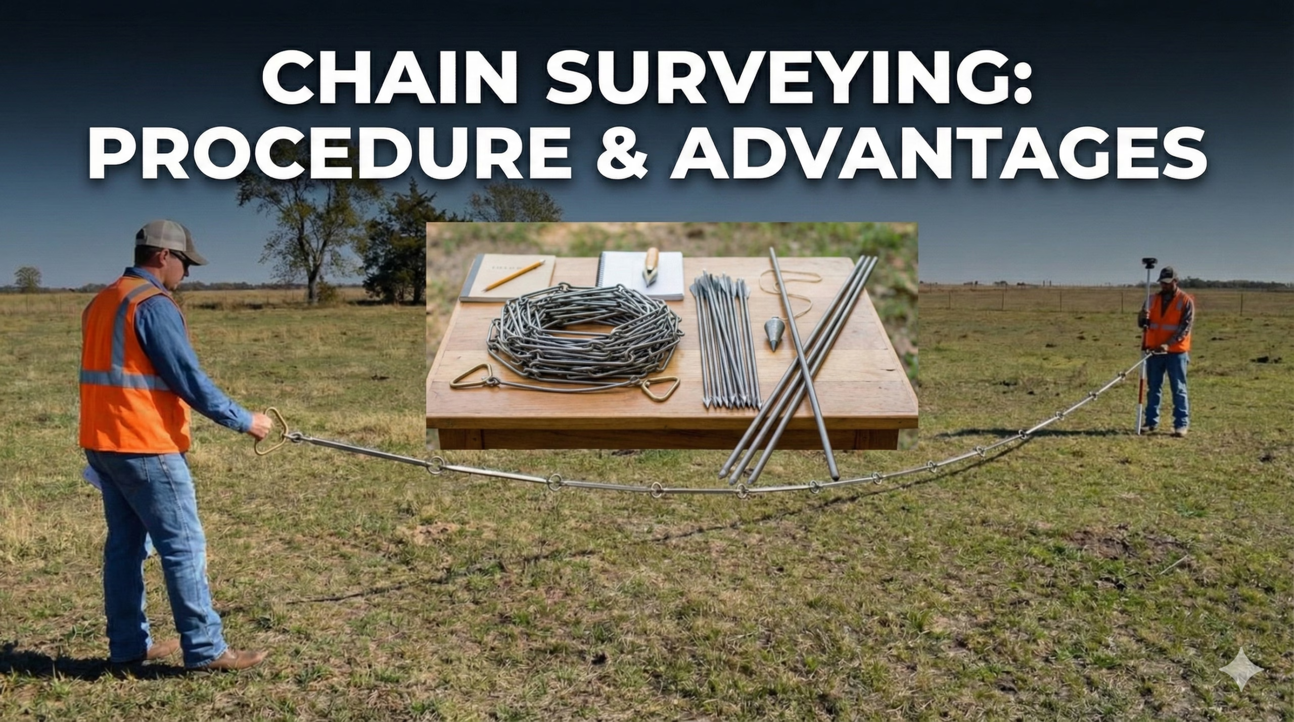
Chain surveying
Chain surveying is the simplest form of surveying and works on the principle of triangulation. Surveyors take only linear measurements, making this method suitable for small, relatively flat areas. They divide the region into triangles and measure the side lengths using chains, arrows, ranging rods, pegs, and similar tools. It is quick and economical but less accurate for large or uneven sites.
Theodolite surveying
Theodolite is a precision instrument used to measure horizontal and vertical angles. This surveying method is highly accurate and supports level difference determination, prolonging survey lines, and setting out works for major constructions such as roads and bridges. It is widely used in both Plane vs Geodetic Surveying applications where better angular accuracy is required.

Traverse survey
In traverse surveying, surveyors form interconnected survey lines to develop a traverse framework. They measure the line lengths directly using tapes or indirectly using Electronic Distance Measurement (EDM). Surveyors commonly apply chain traverse, compass traverse, tape traverse, and plane table traverse methods. They use this technique when a project requires accurate boundary determination and closed-loop precision.
Triangulation Surveying
Triangulation surveying establishes control points by forming a series of triangles between survey stations. Surveyors compute distances and relative locations using trigonometric relations based on measured angles. It is particularly effective in hilly, mountainous, or uneven terrain where direct measurements are difficult.
Tacheometric survey
Tacheometric surveying involves angular measurements taken with a transit theodolite equipped with a stadia diaphragm, enabling calculation of horizontal and vertical distances. It is convenient when direct measurement is challenging—such as steep slopes, obstacles, or inaccessible points—and provides faster results compared to chain surveying.
Plane Table Surveying
Surveyors use plane table surveying as a graphical method, carrying out field observations and plotting simultaneously. It is faster than many other methods and allows easy error detection on-site. This technique is suitable in magnetic zones where compass usage is restricted. Instruments used include plane table, alidade, plumbing fork, plumb bob, spirit level, and compass.
Photogrammetric survey
Photogrammetry uses photographs captured by drones, aircraft or satellites to measure distances and map features. It can produce maps, 3D models, and virtual reconstructions of landscapes and structures. Photogrammetric surveys are highly efficient for covering large areas, environmental studies, and documentation of wildlife and heritage sites. They are also widely used in modern land surveying methods.
Key Takeaways
- Classification of Surveying is crucial in civil engineering for precise measurement and mapping.
- Surveying divides into primary methods like Plane and Geodetic Surveying, based on the Earth’s surface treatment.
- Various classifications based on field nature include land, hydrographic, and astronomical surveying.
- Specific purposes also classify surveying, such as engineering, military, geological, and archaeological surveys.
- Instruments used in surveying vary, with methods like chain, theodolite, and photogrammetric surveys addressing different project needs.
Conclusion
The Classification of Surveying helps engineers clearly understand how they use different surveying approaches across various environments and project needs. By studying the Types of Surveying, professionals can select the most accurate and efficient method for mapping land, measuring distances, and preparing engineering layouts. The distinction between Plane vs Geodetic Surveying ensures that both small-scale and large-scale projects achieve reliable precision. Likewise, choosing the right Land Surveying Methods supports proper planning, construction, and boundary establishment. Modern Surveying Techniques in Civil Engineering such as photogrammetry, GPS and theodolite use have further improved accuracy, safety, and speed. Overall, mastering Methods of Surveying Classification allows surveyors and engineers to deliver better design decisions, greater project efficiency, and high-quality infrastructure development.