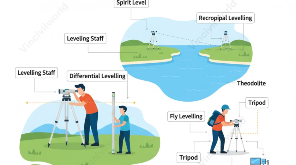
Types of levelling in surveying are fundamental for accurately determining relative heights and elevations in various engineering and construction projects. This comprehensive guide explores essential methods, beginning with differential levelling, a core technique used for precise height transfers across landscapes. We’ll examine the traditional spirit levelling method, a foundational practice that relies on simple yet effective instrumentation. For more challenging scenarios, we’ll delve into reciprocal levelling, a specialized approach designed to overcome obstacles like wide rivers, ensuring accuracy where direct methods fail. Additionally, fly levelling will be discussed as an efficient method for establishing approximate levels over long distances. Finally, a detailed look at the various levelling instruments will illustrate the tools surveyors use to execute these critical operations effectively.
Types of levelling – Levelling is a branch of surveying that deals with computing and determining the relative heights between different points with respect to the datum. The purpose of levelling is for determining the elevation of a point and establishing the same at a given elevation. Moreover levelling deals with the computation of measurements in the vertical plane. There are different types of levelling in Surveying. In this article, we will discuss the purpose and types of levelling.
Table of contents
Purpose of levelling
Levelling accurately determines relative heights and elevations, providing crucial data for engineering, construction, and mapping projects, ensuring stability and proper design.

- Preparation map layouts.
- To determine the elevation of points.
- To prepare contour maps.
- Determination of depth of cutting and filling in earthworks.
- To make the cross-section of canals, roads, etc.
- For establishing control points.
Types of levelling
There are mainly four types of levelling in surveying.
- Barometric levelling
- Trignometric levelling
- Stadia levelling
- Spirit levelling or Direct levelling
Barometric levelling – Types of levelling
Barometric leveling is a type of leveling in which the measurement of elevation is based on atmospheric pressure by using a barometer. Therefore we use a barometer. The main principle of Barometric leveling is the difference between the elevation of two points is proportional to the difference between the atmospheric pressure of the points. Since it is inaccurate, this method of leveling is rarely used. Because leveling takes time and the atmospheric pressure does not remain constant throughout the day. Therefore they give only a rough estimation.
Trigonometric levelling – Types of levelling
Trigonometric levelling is a method of levelling in which the difference in elevation is calculated using the observed vertical angle and known horizontal distance. Another name of trigonometric levelling is Indirect levelling. For vertical angles, generally, we use theodolite. For horizontal distance, if the distance between the points is less, we measure using plane surveying. If the distance between the points is greater, we use geodetic observation.
.
Stadia levelling – Types of levelling
Stadia levelling is similar to trigonometric levelling. To determine the elevation of points, we use a tacheometer. Hence, It is an optical distance measurement method. This type of levelling is suitable in hilly regions. Stadia levelling is an accurate method of levelling. Another name of stadia levelling is Tachometric levelling.
Spirit levelling or Direct levelling method
Direct levelling is also known as spirit levelling method. It is the most precise and commonly used levelling method. In this method, the vertical distance with respect to the horizontal line is taken to determine the relative position between the points. The instruments which are used in Direct levelling are level and a levelling staff. The level consists of a telescope, level tube, levelling head and a tripod. Direct levelling is further divided into
- Simple levelling
- Differential levelling
- Profile levelling
- Reciprocal levelling
- Precise levelling
Simple levelling
It is the simplest method of levelling. In this method, we place the levelling instrument between the points for determining elevation. This type of levelling is suitable if the distance between the points is less.
Differential levelling
Differential levelling is suitable in places where the distance between the points are great. This type of levelling is also known as fly levelling. In differential levelling, the levelling station is shifted various times.
Profile levelling
Another name of profile levelling is longitudinal levelling or sectioning. In this type of levelling, the points are far apart at known distances. So levelling is done at intervals along the given line. It is suitable for roads, canals, sewer lines, railways, etc.
Reciprocal levelling
This type of levelling is done, when it is not possible to set up the level between two points. It is the accurate method of levelling. It is suitable in the place where ponds, rivers are seen.
Precise levelling
This types of levelling have high precision. It is similar to differential levelling. In precise surveying, special equipment and special precaution are taken to eliminate errors.
Key Takeaways
- Types of levelling in surveying are crucial for establishing relative heights and elevations in engineering projects.
- Key methods include differential levelling, spirit levelling, reciprocal levelling, and fly levelling, each catering to different scenarios.
- Barometric levelling relies on atmospheric pressure, while trigonometric levelling uses angles and distances for measurements.
- Stadia levelling employs a tacheometer for accurate elevation assessments, especially in hilly areas.
- Direct levelling is the most precise method and includes variations like simple, differential, profile, reciprocal, and precise levelling.
Conclusion
In conclusion, understanding the diverse types of levelling in surveying is essential for any civil engineering or construction professional. From the foundational precision of differential levelling to the practical applications of the spirit levelling method, each technique plays a vital role in establishing accurate elevations. Specialized approaches like reciprocal levelling provide solutions for complex terrain, while fly levelling offers efficient checks over extensive areas. Mastering these methods, alongside familiarity with various levelling instruments, ensures that projects are built on a solid foundation of precise height data. Ultimately, proficient levelling is not just a technical skill but a critical component for the safety, functionality, and success of any infrastructure endeavor.


